Overlays UR and problem markers onto Livemap
Add-on for the Waze Livemap to show UR and map problem markers. The markers shown on the map can be selected using similar filtering options as found in my UROverview WME add-on.
Well… that is what you call a detailed map.
As you can see by segments, Riff-Raff has drawn most of Kaunas.
Maybe little too detailed. But still ok.
Some places are not very straight, if that is the problem. Should be made straight, to be displayed correctly in client application.
Those house places can be given house name to show it on the map for better orientation, if needed.
A little too much parking lots…
But still better then nothing?
I fully agree that having required details on the map is way better than nothing
Please don’t get me wrong, I appreciate RIFF_RAFF’s (and others) all hard work on drawing maps in Lithuania, but going forward we all should probably feel sake and follow main principles of Waze.
Adding too short road segments (10-15 meters) or ‘Park’ areas everywhere you found a tree is not something very useful in terms of usability. It will result to tiny objects on the smartphone screen
The accuracy of our GPS devices is far from being perfect.
I kind of wanted to point community attention to this. Especially wazers from Kaunas. How do you guys feel about the details ?
P.S. With my level of experience here I don’t feel to be in a position to give advice to senior wazers. This is more like an open discussion to get better understanding. If that’s a good example of editing practice then here I come
I have talked with him, and he promised to take a look at parking lots segments and houses. When he has drawn this, he was the beginner too. Parking lots segments should be minimized a little.
Šiandien atradau vieną įdomų dalyką. Netekau teisių redaguoti kai kurias vietas, kur apsilankiau 2014 metais. Liko tik vietos, kur esu Area Manager. Prie “Drives” seniausias mano maršrutas yra šių metų sausio 15 dienos. Taip supratau, jie nelieka ten visą laiką ir ilgainiui dingsta ?
#1 Taip, redaguojamos vietos dingsta su laiku, dabar tiksliai neprisimenu kas kiek laiko resetinas. Nedingsta tose vietose žinoma, kur reguliariai važinėjama yra. Su AM tas pats, tik AM jei neklystu laikas yra ilgesnis, gal net pusę metų, tiksliai vėlgi nepasakysiu, trumpai tariant visos ribos dingsta, tik CM (Country Manager) nedingsta - tol kol neatimamos teisės.
#2 Gal koordinatės netyčia buvo sumaišytos uždedant AM arba per MapRaid įvyko klaida. Neaišku - nemanau, kad trukdo. Tad ir aiškintis nelabai verta, nebent pastebėsi, kad vėl atsiranda tokios AM vietos, tada jau į supportą galima rašyti ir klausti kokie vėjai darosi.
Pakoregavau kaikuriuos miškus ir vandens telkinius. Mano editoriuje vaizdas atsinaujinęs. Kiek laiko užtrunka pakeitimams atsirasti aplikacijos žemėlapyje?
I’ve altered some forests and bodies of water. They are updated in my editor map. How long does it actually take for those entities to update in the app?
Sveikas, viena iš dažniausiai pasitaikančių priežasčių, tai, kad dingsta GPS signalas ir atsiranda tik pravažiavus. Tad automatiškai gaunasi tokios teleportacijos.
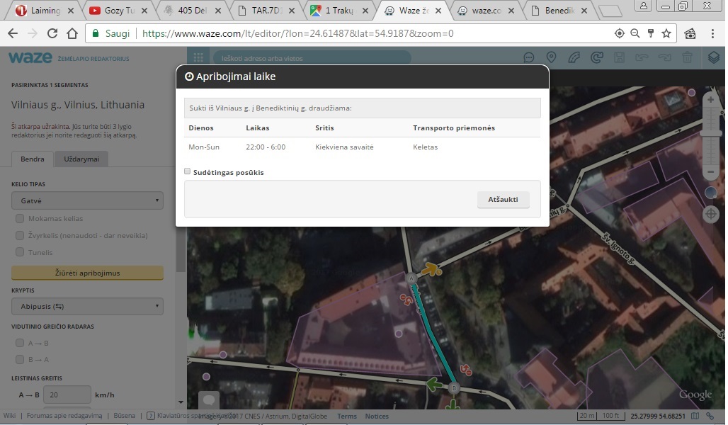
Sveiki, kodėl neleidžia pasukti iš Vilniaus gatvės į benediktinų, net pasirinkus kad esi taxi, veda ratu. Nors praktiškai visam centre po 22 val eismas draudžiamas.
Sveiki.
Ar jūs tikras, kad vidutinio greičio matavimui pasirinkta tik 2,0km ilgio atkarpa?
LAKD paskelbta informacija nurodo, kad vidutinio greičio matavimo ruošas A6 kelyje yra 108,270-112,107 km.
Taip pat pagal pateikiamą informaciją, šiame taške 55.456912, 25.341531 https://www.waze.com/lt/editor?env=row&lon=25.34301&lat=55.45701&zoom=6&nodes=255687492, yra automobilių valstybinių numerių atpažinimo vaizdo kamera bei dar keletas matavimus atliekančių įrenginių. Bet šis taškas nėra nei pradžia, nei pabaiga vidutinio greičio matavimo ruožui.