{{ReturnTo | Junction_Style_Guide | the junction style guide}}
An '''interchange''' is a road junction where two roads are connected by dedicated roadways, called '''ramps'''. The roads connected by an interchange do not intersect one another directly, and if they cross, the crossing is grade-separated.
An '''interchange''' is a road junction where two roads are connected by dedicated roadways, called '''ramps'''. The roads connected by an interchange do not intersect one another directly, and if they cross, the crossing is grade-separated.
Line 23:
Line 24:
The {{Ramp}} type is used extensively in interchanges for three reasons.
The {{Ramp}} type is used extensively in interchanges for three reasons.
* Ramp segment names are not displayed on the map. This
* Ramp segment names are not displayed on the map.
* Ramp segments have essentially no penalty, so they can be used to connect Freeways and Major Highways with each other without causing problems.
* Ramp segments have essentially no penalty, so they can be used to connect Freeways and Major Highways with each other without causing problems.
* Ramp segments are relatively small but show at high zoom levels, so interchanges do not distract from highways but can be seen at high speeds.
* Ramp segments are relatively small but show at high zoom levels, so interchanges do not distract from highways but can be seen at high speeds.
Line 35:
Line 36:
=== Ramp geometry and complexity ===
=== Ramp geometry and complexity ===
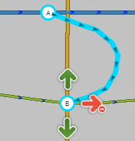
Rule #1 is still simpler is better. If there is no large distance between paths at the end of a ramp (either into or out of the ramp), a single segment connecting to a single junction node is all that is needed. The existence of a painted, concrete, or grass island is '''NOT''' enough of a reason to split a ramp into multiple ramps.
When placing the beginning of a ramp, place the first [[geometry node]] of the ramp segment at the point where the solid white line begins, and extend the ramp naturally to create a junction with the road segment, typically at a 10–15° angle. This will allow for consistent timing of exit instructions.
: [[Image:Exit-ramp-geom.png]]
Do the same when placing the end of a ramp. This will allow for consistent auto-zoom functionality—the client remains zoomed in for the duration of the ramp, zooming out when the user gets on the freeway.
: [[Image:Entrance-ramp-geom.png]]
Rule #1 is still simpler is better. If there is no large distance between paths at the end of a ramp (either into or out of the ramp), a single segment connecting to a single junction node is all that is needed. The existence of a painted, concrete, or grass island is '''NOT''' enough of a reason to divide a ramp into multiple ramps.
: [[Image:Jct_ramp_no_split.png]]
: [[Image:Jct_ramp_no_split.png]]
Line 48:
Line 57:
Specific examples of how to handle common junction types are provided in later sections. All of those examples use the basic building blocks provided here.
Specific examples of how to handle common junction types are provided in later sections. All of those examples use the basic building blocks provided here.
If you are unsure what road type you should use, refer to the following pages for more information.
If you are unsure what road type you should use, refer to the '''[[Road types and names]]''' for your country.
It is a basic Exit situation when a "straight" direction is obvious to a driver and navigation instructions are only needed for the non-straight direction (the exit.) If navigation instructions are required for both directions, see the [[#Wayfinder_Segments|Wayfinder Segments]] section below.
It is a basic Exit situation when a "straight" direction is obvious to a driver and navigation instructions are only needed for the non-straight direction (the exit.) If navigation instructions are required for both directions, see the [[#Wayfinders|Wayfinders]] section below.
==== Exit geometry ====
==== Exit geometry ====
Line 59:
Line 66:
To be treated as a basic Exit, the following must be true:
To be treated as a basic Exit, the following must be true:
# The entering segment and one exiting segment must be one of the three Highway/Freeway types
# The entering segment and the continuing segment must be {{Freeway}}, {{Major Highway}}, or {{Minor Highway}} type,
# The Highway/Freeway exiting segment must have close to a zero degree departure angle from the entering segment
# The Freeway/Highway continuing segment should have close to a zero degree departure angle from the entering segment,
# The other exiting segment must be of the type Ramp
# The other exiting segment must be of the type {{Ramp}}, and
# The Ramp exiting segment must have a departure angle of between 20 and 30 degrees from the entering segment
# The Ramp exiting segment should have a departure angle around 10–15 degrees from the entering segment, as explained above.
When those conditions are met, the navigation will present an "Exit Right/Left" instruction when the ramp is to be used, and will remain silent when the exiting Highway/Freeway segment is to be used.
When those conditions are met, the navigation will present an "Exit Right/Left" instruction when the ramp is to be used, and will remain silent when the continuing Freeway/Highway segment is to be used.
==== Exit naming ====
==== Exit naming ====
Line 71:
Line 78:
[[Road names/USA#Exit_ramps_and_Entrance_ramps_.28on-ramps.29|US Specific Ramp Names]]
[[Road names/USA#Exit_ramps_and_Entrance_ramps_.28on-ramps.29|US Specific Ramp Names]]
[[How_to_label_and_name_roads_%28United_Kingdom%29#Ramps_.28to.2Ffrom_Motorways_and_Dual_Carriageways.29|UK Specific Ramp Names]]
[[United Kingdom/Roads#Ramps_.28to.2Ffrom_Motorways_and_Dual_Carriageways.29|UK Specific Ramp Names]]
[[Road types and names|Naming standards for other areas]]
[[Road types and names|Naming standards for other areas]]
Line 77:
Line 84:
Editors covering areas that do not have specific best practices should review the existing guides for other areas, and determine which best matches the roadways of your area.
Editors covering areas that do not have specific best practices should review the existing guides for other areas, and determine which best matches the roadways of your area.
A Highway/Freeway Split is when a Highway/Freeway segment meets at a junction with two other Highway/Freeway segments and there is no obvious straight through direction to a driver.
A Highway/Freeway Fork is when a Highway/Freeway segment meets at a junction with two other Highway/Freeway segments and there is no obvious straight through direction to a driver. This is synonymous with the MUTCD term "split".
To receive a navigation instruction for '''both''' branches of a split, the following must be true:
To receive a navigation instruction for '''both''' branches of a fork, the following must be true:
# All segments must be one of the three Highway/Freeway Types
# Both exiting segments must be the same type (Freeway, Major Highway, Minor Highway).
# All segments must have names which are different from each other
# Each exiting segment must have a name which is different from the name of the entering segment.
# The two exiting segments must have departure angles of 20 to 30 degrees from the entering segment
# The two exiting segments should have departure angles around 10 to 15 degrees from the entering segment.
With those conditions met, the junction will present "Keep Left" and "Keep Right" navigation instructions using the name of the appropriate exiting segment.
With those conditions met, the junction will present "stay to the left" and "stay to the right" navigation instructions using the name of the appropriate exiting segment.
The primary rule is that all 3 segments at the junction must have different names. That can be accomplished in one of two ways:
The primary rule is that all 3 segments at the junction must have different names. That can be accomplished in one of two ways:
# Using road names alone - It is an easy situation if all three roads which connect have different names. If "Highway A" splits into "Highway B" and "Highway C", then that is all we need to have a properly functioning split.
# Using road names alone - It is an easy situation if all three roads which connect have different names. If "Highway A" forks into "Highway B" and "Highway C", then that is all we need to have a properly functioning fork.
# Using signs and [[#Wayfinder_Segments|Wayfinder Segments]] - If one of the branches of the split has the same name as the entering segment, we must create uniqueness at the junction. If "Highway X" splits off from "Highway Y" and "Highway X" continues as the other branch, the preferred approach is to use named [[#Wayfinder_Segments|Wayfinder Segments]].
# Using signs and [[#Wayfinders|Wayfinder Segments]] - If one of the branches of the fork has the same name as the entering segment, we must create uniqueness at the junction. If "Highway X" forks off from "Highway Y" and "Highway X" continues as the other branch, the preferred approach is to use named [[#Wayfinders|Wayfinder Segments]].
A '''wayfinder''' gives a user an instruction directing them how to continue on the road the user is already on, in situations where it may be unclear, and there would otherwise be no instruction.
==== Terminology ====
A '''travel lane''' is a lane which is long enough that a naïve driver might consider it a long-distance lane. For our purposes we will clarify this as any lane which;
#before nearing the exit, is neither striped nor signed as a departing lane over a significant length (approximately ¾ a mile, or its full length, whichever is shorter), and
#has not just started within a mile before the exit.
The '''typical side''' for an exit depends on the traffic side for that country. In a country with [[Right-hand traffic]] i.e. the USA, the typical side for an exit is the right side.
The '''atypical side''' for an exit is the opposite of the typical side described above.
A '''continuation path''' or '''continuation''' is the group of lanes after the fork which continue to be the same road as it was before the fork. (In the following example, the lanes which continue to be I-47)
*The continuation path on a controlled-access highway or freeway, when an exit is present on the typical side, has at least two fewer ''travel lanes'' after the exit than before it;
*The continuation path on a controlled-access highway or freeway has the same number of lanes as, or fewer lanes than, the exit path after the fork;
*The continuation path on an uncontrolled highway, or when an exit is present on the atypical side of a controlled-access highway or freeway, has at least one fewer ''travel lane'' after the exit than before it;
*The continuation path consists of a single lane; or
*Other conditions exist that may suggest a fork, rather than an exit (use your better judgement, and discretion) -- for example:
**The physical roadway itself forks or diverges with no clear straight-ahead direction;
**The road which appears to be straight ahead is not the actual continuation;
**Signage and striping do not clearly provide all expected "exit" indications, or do so inconsistently; or
**Signs are present with arrows pointing left and right but no sign clearly establishes the continuation.
{{NeedImage| Need sample images for "lane drops" and "non-obvious continuations"; also, example of BGS with lane arrows}}
[[File:FreewayS-inS-out.png|200px|right]]
In these cases, we need to use a wayfinder configuration. Each wayfinder configuration will have one "IN" segment and two "OUT" segments.
==== Configuration ====
These configurations have been designed based on a very in-depth understanding of [[How_Waze_determines_turn_/_keep_/_exit_maneuvers|Waze's standard rules for generating instructions]]. Please don't deviate from these precise configurations.
It may be necessary to provide additional information to a driver for complex or confusing [[#Highway.2FFreeway_Exits|Exits]] and [[#Highway.2FFreeway_Splits|Splits]]. Examples of such situations include:
* Each "stub" segment should be {{:Segment length/Minimum}} long. This is long enough so it will not cause routing problems, but it is short enough to suppress display of the names (on Freeway stubs) and keep freeways looking contiguous (on Ramp stubs).
* '''Lane Drops''' - Highway has been 3 lanes for miles and miles but only 2 lanes continue straight through at a certain point
* The OUT segments should have a ''turn angle'' of 10°-20° off of the mid-line on opposite sides of each other, consistent with [[Junction_Style_Guide/Interchanges#Freeway_split_geometry|the geometry for freeway forks]]. This will allow for easy identification in WME, but still look seamless in the client app.
* '''Inconsistent signage''' - Highway continues as a numbered route, but signs only call it by a name instead
* '''Non-obvious continuations''' - in a right hand drive country, exiting traffic is to the left and continuing traffic is to the right
In these cases we need to use short way-finder or path-finder segments which are named with the information displayed on the roadway signs. There are two methods to accomplish this: using Highway/Freeways or using Ramps.
* '''Highway/Freeways'''
To configure the wayfinder,
** Pro: provide a consistently rendered line on the map with no breaks
* If the numbered/signed exit is on the '''right''', the OUT segments should be {{Ramp}} type. This will give an "exit right" instruction for the exit and a "stay to the left" instruction for the continuation.
** Pro: does not introduce a [[Routing_penalties|routing penalty]] for the transition to Ramp type (although we do not know how much of an impact, if any, this has in actuality)
** For a basic [[Junction Style Guide/Interchanges#Exits|exit]], use a named Ramp stub for the continuation, and a standard Ramp for the exit.
** Con: the long name of the segment may be displayed on the map creating clutter
** For a [[Junction Style Guide/Interchanges#Freeway.2Fhighway splits|freeway fork]], use a Ramp stub on both sides.
** Con: the segment may be hard to see in the editor since it may blend in with the main Freeway
* If the numbered/signed exit is on the '''left''', the OUT segments type should be the same as {{Road|style=background-color: #fbe73f;|the IN segment}}, in the following examples we will use the {{Freeway}} type. This will give "stay to the" instructions on both sides (if {{Ramp}} segments were used, Waze would give a confusing "exit right" instruction for the continuation).
** Note: will provide "Keep Left" and "Keep Right" instructions
** For a basic [[Junction Style Guide/Interchanges#Exits|exit]], use a named Freeway stub for the continuation, and an unnamed Freeway stub followed by a named Ramp for the exit.
** For a [[Junction Style Guide/Interchanges#Freeway.2Fhighway splits|freeway fork]], use named Freeway stubs on both sides.
* '''Ramps'''
<div style="font-size:smaller">
** Pro: ensures any long names are hidden from display on the map
{| class="wikitable" style="text-align:center"
** Pro: forces the client to stay zoomed in for the length of the segment to give a close view of the split to the driver
|-
** Con: introduces a [[Routing_penalties|routing penalty]] of the transition to Ramp type (although we do not know how much of an impact, if any, this has in actuality)
! Exit direction
** Con: may render as a broken line on the map
! Type
** Note: will provide "Keep Left" and "Exit Right" instructions in right-hand drive countries and "Exit Left" and "Keep Right" instructions in left-hand drive countries.
| '''Exit side'''<br/>{{Freeway|Unnamed Fwy stub}} → {{Ramp|Named Ramp}}
| '''Continuation side'''<br/>{{Freeway|Named Fwy stub}} → {{Freeway|Named Fwy}}
| [[File:LeftExitRamp.png|190px]]
|-
| Left
| Fwy fork
| '''Exit side'''<br/>{{Freeway|Named Fwy stub}} → {{Freeway|Named Fwy}}
| '''Continuation side'''<br/>{{Freeway|Named Fwy stub}} → {{Freeway|Named Fwy}}
| [[File:LeftExitSplit.png|190px]]
|}
</div>
In both cases, the two exiting segments '''MUST''' have identical road types and different names from themselves and the entering segment.
==== Segment naming ====
Keep these basic principles in mind:
* The OUT segments must both be the same type (either {{Freeway}}, {{Major Highway}}, {{Minor Highway}}, or {{Ramp}}, as explained below).
* Each OUT segment must have a name different than the IN segment.
** '''NOTE:''' An unnamed segment (no-name box checked) is considered to have a blank name, and not the inherited name for these purposes. Therefore either both OUTs must be no-name, or both must have their own unique name.
* OUT segments should be named with the information displayed on the roadway signs.
** However, if this would leave an OUT segment with the same name as the IN segment, the OUT segment should be left unnamed (i.e., check the "no name" box).
Here we show Highway Y splitting off from Highway X. By labeling segments with the information available on the road signs at the split, we have achieved uniqueness and provided additional useful information (the destination cities) to the driver. We can achieve the desired results using either approach. First as all Freeway segments:
{{mbox|type=important|text=Previously in these situations segment naming was modified in one of the following ways {{u|''in order of preference''}}:
#Add a control/destination city, if it is known, to the OUT segment name.
#Remove the compass cardinal from the OUT segment name.
#Add a space to the end of the OUT segment name (note that this will be flagged by the [[Community_Plugins,_Extensions_and_Tools#WME_Validator|WME Validator script]], if active, and possibly result in undoing by another editor)
#Create a stub in the IN segment just before the junction with no street name.
#*'''NOTE:''' This option should only be used as a last resort because it prevents the [[Routing_server|routing server]] from properly calculating [[Turn delays|turn delays]], and may result in inefficient routing through the area.
[[Image:Jct_fwy_fwy_wayfinder_fwy.png]]
If you see any of these set-ups, please correct it to one of the two proper methods listed above.}}
And then using Ramps (which are named how they appear in the all Freeway example):
If the continuation is '''signed''', and a wayfinder is warranted,
* If the continuation sign contains the name or shield of the continuing road, do '''not''' use "to" at the beginning of the name of the OUT segment. e.g., a freeway fork where one side is the continuation of the same freeway (the user is already on the road, not going "to" it). Most wayfinders will fit this criterion.
**If the name of the continuation is included but is not listed first on the sign, move the name of the continuing road to the beginning of the segment name. (e.g. In this wayfinder the highway you are on now, and continuing on is I-275, so the segment name should be "I-275 N / I-74 E / US-52 E / Cincinnati".)
* If the continuation sign '''does not contain''' the name or shield of the continuing road, then the road name should begin with "to".
[[Image:Jct_fwy_fwy_wayfinder_rmp.png]]
At times it is also necessary to use a way-finder at an Exit if a driver needs advance notice that only some lanes of the roadway continue straight through. Again we can accomplish this using either of the two methods. First using Freeway segments for the split (the right branch wayfinder is un-named and the ramp segment that follows contains the appropriate name):
If the word "TO" is explicitly included on the continuation sign,
* [[File:Wayfinder To BGS.png|300px|thumbnail|right]]Move the shields or names affected by the "TO" to the end of the segment name after a slash (/). (The example BGS shown is for the continuation of I-80, which leads to I-280, with a control city Morristown.)
** If any included control cities or road names correlate only to the roads affected by the "TO", then those control cities or road names should be moved after the "/ to [road(s)] /" on the segment name.
*** [[File:Wayfinder To WME.png|300px|thumbnail|right]] If Morristown is served by I-80, the continuation segment should be named '''"I-80 / Morristown / to I-280"'''.
** If any included control cities or road names correlate to the roads '''not''' affected by the "TO", then those control cities or road names should remain in place before "/ to [road(s)]".
*** If Morristown is served by I-280 and ''not'' by I-80, the continuation segment should be '''"I-80 / to I-280 / Morristown"'''.{{clear}}
[[Image:Jct_fwy_rmp_wayfinder_fwy.png]]
And then using Ramps (again, named the same as above):
If the continuation is '''not signed''', and a wayfinder is warranted,
** If the OUT segment is a continuation of the same road, it should be left unnamed (check the "no name" box).
** If the OUT segment is an exit, it should be named following the guidelines for an unsigned exit.
** If the OUT segment is a short continuation of the same road leading to another road, name the segment starting with "to" followed by the name of the road to which the continuation leads, following these guidelines:
*** {{anchor|no BGS to}}[[File:No BGS To exit.PNG|300px|thumbnail|right]]Where the wayfinder is just before, but not at, the termination of a road, so the continuation OUT segment is named for the road that the continuation leads to at the termination. However you still must travel for a short distance on the continuation of this road until those exits/termination. [[File:No BGS To exit zoom out.PNG|300px|thumbnail|right]]Our example here is a wayfinder on US-1-9 N (Truck), the left OUT is the continuation, however the right OUT also continues on the same road until it intersects with SR-440, with an exit to SR-440 S along this short segment. There are no roadway signs for any of these forks, or exits/terminations. The OUT segment here would be named '''"to SR-440 S / Communipaw Ave"''', and the SR-440 exit will be named following the [[Road_Names_(USA)#Exit_ramps_and_entrance_ramps_.28on-ramps.29|unsigned exit guidelines]]. However it may be appropriate (if there are no House Numbers, or other on ramps past this wayfinder before it reaches the exit, to leave this entire portion with no name, and the instruction will inherit the name of the next road to which you are going.{{clear}}
[[Image:Jct_fwy_rmp_wayfinder_rmp.png]]
A rule of thumb for the way-finder segments is to make them 15 to 20 meters long. This keeps the segment small so we are less likely to see it in the client, but keeps it long enough to find and manipulate in the map editor. (In the near future, Way-finder segments may need to be greater than 5 meters long to prevent routing issues.)
Wayfinder naming examples
<div style="font-size:smaller">
{| class="wikitable" style="text-align:center"
|-
! #
! Continuation sign
! Continuing road name
! Rule
! Waze road name
|-
| colspan="3" | [[File:Wayfinder I-10 BGS.png|225px|thumbnail|center]]
| [[File:Wayfinder continue last WME.png|225px|thumbnail|center]]
|-
| 3
| I-74 E / US-52 E / I-275 N / Cincinnati
| I-275 N
| Included but not first – move to beginning
| '''I-275 N / I-74 E / US-52 E / Cincinnati'''
|-
! #
! Continuation sign
! Continuing road name
! Rule
! Waze road name
|-
| colspan="3" | BGS image
| WME image
| context image
|-
| 4
|
|
|
| '''name'''
|-
! #
! Continuation sign
! Continuing road name
! Rule
! Waze road name
|-
| colspan="3" | image
| image
| image
|-
| 5
|
|
|
| '''name'''
|}
</div>
=== Ramp-ramp splits ===
=== Ramp-ramp forks ===
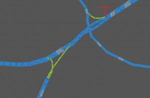
A ramp may itself split and branch into two directions. If this is the case, "Exit Right" and "Exit Left" will be announced using the name of the appropriate exiting segment in all cases.
A ramp may itself fork and branch into two directions. If this is the case, "Exit Right" and "Exit Left" will be announced using the name of the appropriate exiting segment in all cases.
==== Ramp split geometry ====
==== Ramp fork geometry ====
: [[Image:Jct_ramp_ramp_split.png]]
: [[Image:Jct_ramp_ramp_split.png]]
==== Ramp split naming ====
==== Ramp fork naming ====
If ramps are unnamed, the name of a subsequent ramp will propagate backwards. In the example above, if the two ramps exiting the junction are named, the ramp entering the junction can be left unnamed. Then any navigation instruction directing you onto the first ramp would use the name of the appropriate exiting ramp.
If ramps are unnamed, the name of a subsequent ramp will propagate backwards. In the example above, if the two ramps exiting the junction are named, the ramp entering the junction can be left unnamed. Then any navigation instruction directing you onto the first ramp would use the name of the appropriate exiting ramp.
'''Example:''' The two ramps exiting the junction are named "DestinationLeft" and "DestinationRight". The ramp that enters the junction is unnamed. If you need to "Exit Right" onto the unnamed ramp. If you are headed to "DestinationLeft", navigation would tell you:
'''Example:''' The two ramps exiting the junction are named "DestinationLeft" and "DestinationRight". The ramp that enters the junction is unnamed. If you need to "Exit Right" onto the unnamed ramp. If you are headed to "DestinationLeft", navigation would tell you:
* Exit Right to Destination Left
* Exit Right to Destination Left
* Exit Left to Destination Left
* Keep Left to Destination Left
Using unnamed ramps is very useful to provide sufficient notification of an approaching decision point, as long as the names of both ramp splits are visible on signs at the start of the initial ramp.
Using unnamed ramps is very useful to provide sufficient notification of an approaching decision point, as long as the names of both ramp forks are visible on signs at the start of the initial ramp.
'''Example of good use of unnamed ramps:'''
'''Example of good use of unnamed ramps:'''
Line 164:
Line 344:
* Destination Left Sign: to Downtown
* Destination Left Sign: to Downtown
* Destination Right Sign: to Center St
* Destination Right Sign: to Center St
Result: An unnamed ramp may create confusion since both Destination ramp names are NOT listed on the initial exit sign. In this case the initial ramp should be named.
Result: An unnamed ramp may create confusion, since both destination ramp names are NOT listed on the initial exit sign. In this case, the initial ramp should be named.
'''Example of modified use of unnamed ramps:'''
'''Example of modified use of unnamed ramps:'''
Line 190:
Line 370:
: [[Image:Jct_diamond_simple_turns.png]]
: [[Image:Jct_diamond_simple_turns.png]]
If the ramps connect to the surface street at multiple points, ramp-to-ramp routing should be avoided as well as illegal turns which should use another ramp. Review the section [[Junction_Style_Guide#How_complex_should_ramps_be?|How complex should ramps be?]] in the Junction Style Guide for more details on this topic.
If the ramps connect to the surface street at multiple points, ramp-to-ramp routing should be avoided as well as illegal turns which should use another ramp. Review the section [[Junction Style Guide#How complex should ramps be?|How complex should ramps be?]] in the Junction Style Guide for more details on this topic.
First we see the turns that must be restricted for the exit ramps:
First we see the turns that must be restricted for the exit ramps:
Line 221:
Line 401:
# (top) we can have the inner entrance and exit ramps have their own junction nodes with the Freeway. Do '''NOT''' use this approach if there are [[#Collector.2FDistributor_Lanes|Collector/Distributor Lanes]] (or a similar situation) involved.
# (top) we can have the inner entrance and exit ramps have their own junction nodes with the Freeway. Do '''NOT''' use this approach if there are [[#Collector.2FDistributor_Lanes|Collector/Distributor Lanes]] (or a similar situation) involved.
# (bottom) we can have the entrance and exit ramps share a single junction node with the Freeway. This allows us to eliminate the very short Freeway segment that may exist between the inner entrance and exit ramps.<br />It is best to offset this shared junction onto the Entrance ramp side of the surface street. This prevents the junction from accidentally being connected to the surface street or looking like it does. We favor the Entrance ramp side, because this would result in a slightly earlier exit instruction which is of course preferred over a late exit instruction.
# (bottom) we can have the entrance and exit ramps share a single junction node with the Freeway. This allows us to eliminate the very short Freeway segment that may exist between the inner entrance and exit ramps.<br />It is best to offset this shared junction onto the Entrance ramp side of the surface street. This prevents the junction from accidentally being connected to the surface street or looking like it does. We favor the Entrance ramp side, because this would result in a slightly earlier exit instruction which is, of course, preferred over a late exit instruction.
The determining factor of which design to use will partly depend on the actual size and scale of the specific interchange and if there is a [[#Collector.2FDistributor_Lanes|Collector/Distributor]] involved.
The determining factor of which design to use will partly depend on the actual size and scale of the specific interchange and if there is a [[#Collector.2FDistributor_Lanes|Collector/Distributor]] involved.
Line 238:
Line 418:
: [[Image:Jct_folded_diamond_u-turn.png]]'
: [[Image:Jct_folded_diamond_u-turn.png]]'
Like with a basic Diamond Interchange, often it will be necessary to represent the ramps making multiple connections to the surface street. Be sure to read the article [[Junction_Style_Guide#How_complex_should_ramps_be?|How complex should ramps be?]] in the Junction Style Guide.
Like with a basic Diamond Interchange, often it will be necessary to represent the ramps making multiple connections to the surface street. Be sure to read the article [[Junction_Style_Guide#Simple_is_better|Simple is better]] in the Junction Style Guide.
Restrict all non-permitted turns.
Restrict all non-permitted turns.
Line 271:
Line 451:
The two surface street segments (between the outer ramps and connected to the Single Point) and the 4 ramp segments connected to the single point should all be the same level, either one higher or one lower than the elevation of the freeway segments above/below the single point.
The two surface street segments (between the outer ramps and connected to the Single Point) and the 4 ramp segments connected to the single point should all be the same level, either one higher or one lower than the elevation of the freeway segments above/below the single point.
=== Collector/distributor interchanges ===
=== Collector/Distributor Lanes ===
These are lanes parallel to but physically separated from the lanes of a Limited Access Road that serve to keep merging traffic out of the flow of through traffic on the mainline Freeway.
These are lanes parallel to, but physically separated from, the lanes of a Freeway that serve to keep merging traffic out of the flow of through traffic on the mainline Freeway.
==== Collector/distributor cloverleaf ====
Collector/distributor lanes serve as either:
* some of the ramps in an '''interchange''', or
* local lanes in configurations with '''[[wikipedia:local-express lanes|local-express lanes]]'''.
This is a Cloverleaf interchange that is connected to a Collector/Distributor instead of directly to the main roadway. Here is an example which matches the physical world but has a major deficiency.
[[Image:Jct_fc_cloverleaf_bad.png]]
==== Collector/distributor interchanges ====
At first it appears that this layout allows everyone to get where they are going. The problem is that it allows MORE than it should. It is possible to exit the mainline Freeway and stay on the Collector/Distributor, bypassing the Cloverleaf, and merge back onto the mainline Freeway.
Some interchange configurations make use of collector/distributor lanes to separate lower-speed merging traffic from high-speed through traffic. This is often used in cloverleaf interchanges and in groups of nearby exits.
Although this may be a way to avoid traffic on the mainline Freeway, doing so is inefficient, may be unsafe, and is outright illegal in some areas. Therefore we need to tweak our design a little...
===== Collector/distributor cloverleaf =====
[[Image:Jct_fc_cloverleaf_good.png]]
This is a cloverleaf interchange that is connected to a collector/distributor instead of directly to the main roadway. Map collector-distributor cloverleaf ramps as you would any other ramp.
In this example, we have eliminated the ramp segment joining the two loops of the cloverleaf and the Collector/Distributor ramps. Now they all connect at a single point and we are therefore able to restrict the turn that allowed drivers to use the Collector/Distributor as a bypass.
[[Image:Jct_fc_cloverleaf_bad.png]]
==== Complex collector/distributor ====
A Collector/Distributor is considered complex if there are multiple exits and entrances connected to the Collector/Distributor.
The [[Detour Prevention Mechanisms|detour prevention mechanism]] will prevent Waze from routing users onto the collector-distributor and back onto the freeway – as long as the city name on the freeway is the same (or set to "no city") before, throughout, and after the collector-distributor. Previously this feature was not available and the ramps were set up to restrict the through route. Some of these ramp configurations may still be set up that way, so they can now be configured as pictured above with the through route enabled.
Ideally you will '''not''' have to implement any of the complex layouts described in this section. Start by representing the ramps in the simplest manner possible and see how they perform for a while. If everything is mapped correctly and navigation still tries to have drivers bypass the mainline Freeway, then and only then modify the layout with the following suggestions.
If we are lucky, we can still restrict the bypass movement with the single central node like we did for the [[#Collector.2FDistributor_Cloverleaf|Collector/Distributor Cloverleaf]] example. Notice how all the exits are either before or at the central node (highlighted in the next image) and all the entrances are at or after the central node.
[[Image:Collector-distributor-exit.png|thumb|right|450px|Collector-distributor lanes used in an interchange on I-81 in Christiansburg, Virginia (Exits 118A-B-C)]]
[[Image:Jct_cmplx_collector_1.png]]
Where collector/distributor lanes are used as part of an interchange, use the {{Ramp}} type for the collector/distributor lanes. Name the ramp segments as you would any other ramp segment.
It becomes more complicated if entrances and exits are more mixed. In the following example, there is an entrance before an exit and the highlighted path shows this entering traffic crossing the exiting traffic we dealt with in previous examples. If we use the same restricted turn on the same node as in previous examples, we block traffic entering from the right-most entrance from being able to get to the mainline Freeway. If we enable that turn, now we are no longer blocking the bypass movement.
Ensure that the city name on the Freeway segments is consistent before and after the collector/distributor lanes, so that the [[Detour Prevention Mechanisms|detour prevention mechanism]] will prevent Waze from routing users erroneously.
[[Image:Jct_cmplx_collector_2a.png]]
{{clear}}
To get the control we require, we need to run the entrance ramp up to the node of the last exit. This allows the exiting traffic to be kept separate from the entering traffic. In the next example, we have modified the right-most entrance so it connects further down the Collector/Distributor. Even if the Collector/Distributor itself is only one lane, we want to have these parallel road segments through the area. They can be close together, but do not overlap them. You will have segments overlapping, but be sure not to junction them together.
==== Local-express lanes ====
[[Image:Jct_cmplx_collector_2b.png]]
[[Image:Local-express.png|thumb|right|450px|A local-express lane configuration on I-96 in Livonia, Michigan]]
Now we can restrict the exiting traffic from using the Collector/Distributor as a bypass of the mainline Freeway as we have previously without impacting the entering traffic.
Local-express lanes are similar to collector/distributor interchange, but on a larger scale. While collector/distributor interchanges typically have an exit number or numbers, local-express lanes typically share the same name, differentiated by "Local" for the collector/distributor lanes and "Express" for the thru lanes.
In a more complicated case, you will need to create parallel paths for exiting and entering traffic for a majority of the Collector/Distributor's length. In the following example, the path for exiting traffic is highlighted and the ramps available for entering traffic appear normally. There is no mixing of entering and exiting traffic in this logical view of the Collector/Distributor even if traffic is mixing in reality.
A local-express lane configuration is not technically an "interchange"; however, since its physical characteristics are similar to those of a complex collector/distributor interchange, it is discussed here.
[[Image:Jct_cmplx_collector_3.png]]
Where collector/distributor lanes are used as part of a local-express lane configuration,
*use the same type (most likely {{Freeway}}) for the Local lanes as is used for the Express lanes, and
*name the road as it is signed: typically "[Name] Local [Direction]": for example, "I-96 Local W" (and "I-96 Express W" for the Express lanes).
As a worse case scenario, you may have a situation where traffic can enter early in the Collector/Distributor and can legally exit at any of the exits along the Collector/Distributor. In this case you will need to carefully create junctions with restricted turns or even additional ramps to enable the legal movements.
{{clear}}
== See also ==
== See also ==
Review the [http://en.wikipedia.org/wiki/Interchange_(road) Wikipedia article on Road Interchanges] for further information on this topic.
Review the [http://en.wikipedia.org/wiki/Interchange_(road) Wikipedia article on Road Interchanges] for further information on this topic.
[[Category:Style Guides]]
Latest revision as of 08:30, 21 June 2015
This revision of a section is currently undergoing modifications. The information presented should be considered a draft, not yet ready for use. Content is being prepared by one or more users. Do not make any changes before you send a private message to this user. Please use the talk page for thoughts and ideas on setting up this content.
An interchange is a road junction where two roads are connected by dedicated roadways, called ramps. The roads connected by an interchange do not intersect one another directly, and if they cross, the crossing is grade-separated.
Since interchanges often involve grade-separated crossings, the road elevation of the segments becomes important. If two roads cross without connecting directly, their elevations must be different.
This article is a sub-article of the Junction Style Guide. As such, this article is a Style Guide as well. The following sections discuss the proper style for ramps, interchanges, and some common Interchange designs. Note that some interchanges may be a hybrid of these basic designs where one side or quadrant of the interchange may differ from the others.
Before reading through this article, be sure to fully understand the information in the Junction Style Guide.
Ramps
Ramps have a very specific purpose in Waze. They are intended to connect segments of Minor Highways, Major Highways, and Freeways to roads where there are no at-grade crossings.
The Ramp type is used extensively in interchanges for three reasons.
Ramp segment names are not displayed on the map.
Ramp segments have essentially no penalty, so they can be used to connect Freeways and Major Highways with each other without causing problems.
Ramp segments are relatively small but show at high zoom levels, so interchanges do not distract from highways but can be seen at high speeds.
When to use ramps
Use of the Ramp type is governed by the following rules:
When placing the beginning of a ramp, place the first geometry node of the ramp segment at the point where the solid white line begins, and extend the ramp naturally to create a junction with the road segment, typically at a 10–15° angle. This will allow for consistent timing of exit instructions.
Do the same when placing the end of a ramp. This will allow for consistent auto-zoom functionality—the client remains zoomed in for the duration of the ramp, zooming out when the user gets on the freeway.
Rule #1 is still simpler is better. If there is no large distance between paths at the end of a ramp (either into or out of the ramp), a single segment connecting to a single junction node is all that is needed. The existence of a painted, concrete, or grass island is NOT enough of a reason to divide a ramp into multiple ramps.
When paths at the end of the ramp deviate significantly in distance, regardless of the existence of any type of island, then multiple ramps should be used.
Interchange types
These are junctions involving the three Highway/Freeway road types - Minor Highway , Major Highway , and Freeway -- as well as their Ramps .
Specific examples of how to handle common junction types are provided in later sections. All of those examples use the basic building blocks provided here.
If you are unsure what road type you should use, refer to the Road types and names for your country.
Exits
It is a basic Exit situation when a "straight" direction is obvious to a driver and navigation instructions are only needed for the non-straight direction (the exit.) If navigation instructions are required for both directions, see the Wayfinders section below.
Exit geometry
To be treated as a basic Exit, the following must be true:
The entering segment and the continuing segment must be Freeway , Major Highway , or Minor Highway type,
The Freeway/Highway continuing segment should have close to a zero degree departure angle from the entering segment,
The other exiting segment must be of the type Ramp , and
The Ramp exiting segment should have a departure angle around 10–15 degrees from the entering segment, as explained above.
When those conditions are met, the navigation will present an "Exit Right/Left" instruction when the ramp is to be used, and will remain silent when the continuing Freeway/Highway segment is to be used.
Exit naming
The Highway/Freeway segments before and after the junction should be named the same. The ramp segments should be named in accordance with the best practices in your location.
Editors covering areas that do not have specific best practices should review the existing guides for other areas, and determine which best matches the roadways of your area.
Freeway/highway forks
A Highway/Freeway Fork is when a Highway/Freeway segment meets at a junction with two other Highway/Freeway segments and there is no obvious straight through direction to a driver. This is synonymous with the MUTCD term "split".
Freeway fork geometry
To receive a navigation instruction for both branches of a fork, the following must be true:
Both exiting segments must be the same type (Freeway, Major Highway, Minor Highway).
Each exiting segment must have a name which is different from the name of the entering segment.
The two exiting segments should have departure angles around 10 to 15 degrees from the entering segment.
With those conditions met, the junction will present "stay to the left" and "stay to the right" navigation instructions using the name of the appropriate exiting segment.
Freeway fork naming
The primary rule is that all 3 segments at the junction must have different names. That can be accomplished in one of two ways:
Using road names alone - It is an easy situation if all three roads which connect have different names. If "Highway A" forks into "Highway B" and "Highway C", then that is all we need to have a properly functioning fork.
Using signs and Wayfinder Segments - If one of the branches of the fork has the same name as the entering segment, we must create uniqueness at the junction. If "Highway X" forks off from "Highway Y" and "Highway X" continues as the other branch, the preferred approach is to use named Wayfinder Segments.
Wayfinders
This revision of a section is currently undergoing modifications. The information and guidance is currently considered accurate enough to be followed now. This content is open to changes from anyone during construction. If you would like to make changes or have questions, please post a message in this forum.
A wayfinder gives a user an instruction directing them how to continue on the road the user is already on, in situations where it may be unclear, and there would otherwise be no instruction.
Terminology
A travel lane is a lane which is long enough that a naïve driver might consider it a long-distance lane. For our purposes we will clarify this as any lane which;
before nearing the exit, is neither striped nor signed as a departing lane over a significant length (approximately ¾ a mile, or its full length, whichever is shorter), and
has not just started within a mile before the exit.
The typical side for an exit depends on the traffic side for that country. In a country with Right-hand traffic i.e. the USA, the typical side for an exit is the right side.
The atypical side for an exit is the opposite of the typical side described above.
A continuation path or continuation is the group of lanes after the fork which continue to be the same road as it was before the fork. (In the following example, the lanes which continue to be I-47)
Criteria (US)
A wayfinder is warranted in the following cases:
The continuation path on a controlled-access highway or freeway, when an exit is present on the typical side, has at least two fewer travel lanes after the exit than before it;
The continuation path on a controlled-access highway or freeway has the same number of lanes as, or fewer lanes than, the exit path after the fork;
The continuation path on an uncontrolled highway, or when an exit is present on the atypical side of a controlled-access highway or freeway, has at least one fewer travel lane after the exit than before it;
The continuation path consists of a single lane; or
Other conditions exist that may suggest a fork, rather than an exit (use your better judgement, and discretion) -- for example:
The physical roadway itself forks or diverges with no clear straight-ahead direction;
The road which appears to be straight ahead is not the actual continuation;
Signage and striping do not clearly provide all expected "exit" indications, or do so inconsistently; or
Signs are present with arrows pointing left and right but no sign clearly establishes the continuation.
Need sample images for "lane drops" and "non-obvious continuations"; also, example of BGS with lane arrows
In these cases, we need to use a wayfinder configuration. Each wayfinder configuration will have one "IN" segment and two "OUT" segments.
Each "stub" segment should be 5 m (16 feet) long. This is long enough so it will not cause routing problems, but it is short enough to suppress display of the names (on Freeway stubs) and keep freeways looking contiguous (on Ramp stubs).
The OUT segments should have a turn angle of 10°-20° off of the mid-line on opposite sides of each other, consistent with the geometry for freeway forks. This will allow for easy identification in WME, but still look seamless in the client app.
To configure the wayfinder,
If the numbered/signed exit is on the right, the OUT segments should be Ramp type. This will give an "exit right" instruction for the exit and a "stay to the left" instruction for the continuation.
For a basic exit, use a named Ramp stub for the continuation, and a standard Ramp for the exit.
For a freeway fork, use a Ramp stub on both sides.
If the numbered/signed exit is on the left, the OUT segments type should be the same as the IN segment , in the following examples we will use the Freeway type. This will give "stay to the" instructions on both sides (if Ramp segments were used, Waze would give a confusing "exit right" instruction for the continuation).
For a basic exit, use a named Freeway stub for the continuation, and an unnamed Freeway stub followed by a named Ramp for the exit.
For a freeway fork, use named Freeway stubs on both sides.
Exit direction
Type
Left OUT configuration
Right OUT configuration
Example
Right
Basic exit
Continuation side Named Ramp stub → Named Fwy
Exit side Named Ramp
Right
Fwy fork
Continuation side Named Ramp stub → Named Fwy
Exit side Named Ramp stub → Named Fwy
Left
Basic exit
Exit side Unnamed Fwy stub → Named Ramp
Continuation side Named Fwy stub → Named Fwy
Left
Fwy fork
Exit side Named Fwy stub → Named Fwy
Continuation side Named Fwy stub → Named Fwy
Segment naming
Keep these basic principles in mind:
The OUT segments must both be the same type (either Freeway , Major Highway , Minor Highway , or Ramp , as explained below).
Each OUT segment must have a name different than the IN segment.
NOTE: An unnamed segment (no-name box checked) is considered to have a blank name, and not the inherited name for these purposes. Therefore either both OUTs must be no-name, or both must have their own unique name.
OUT segments should be named with the information displayed on the roadway signs.
However, if this would leave an OUT segment with the same name as the IN segment, the OUT segment should be left unnamed (i.e., check the "no name" box).
Previously in these situations segment naming was modified in one of the following ways in order of preference:
Add a control/destination city, if it is known, to the OUT segment name.
Remove the compass cardinal from the OUT segment name.
Add a space to the end of the OUT segment name (note that this will be flagged by the WME Validator script, if active, and possibly result in undoing by another editor)
Create a stub in the IN segment just before the junction with no street name.
NOTE: This option should only be used as a last resort because it prevents the routing server from properly calculating turn delays, and may result in inefficient routing through the area.
If you see any of these set-ups, please correct it to one of the two proper methods listed above.
If the continuation is signed, and a wayfinder is warranted,
If the continuation sign contains the name or shield of the continuing road, do not use "to" at the beginning of the name of the OUT segment. e.g., a freeway fork where one side is the continuation of the same freeway (the user is already on the road, not going "to" it). Most wayfinders will fit this criterion.
If the name of the continuation is included but is not listed first on the sign, move the name of the continuing road to the beginning of the segment name. (e.g. In this wayfinder the highway you are on now, and continuing on is I-275, so the segment name should be "I-275 N / I-74 E / US-52 E / Cincinnati".)
If the continuation sign does not contain the name or shield of the continuing road, then the road name should begin with "to".
If the word "TO" is explicitly included on the continuation sign,
Move the shields or names affected by the "TO" to the end of the segment name after a slash (/). (The example BGS shown is for the continuation of I-80, which leads to I-280, with a control city Morristown.)
If any included control cities or road names correlate only to the roads affected by the "TO", then those control cities or road names should be moved after the "/ to [road(s)] /" on the segment name.
If Morristown is served by I-80, the continuation segment should be named "I-80 / Morristown / to I-280".
If any included control cities or road names correlate to the roads not affected by the "TO", then those control cities or road names should remain in place before "/ to [road(s)]".
If Morristown is served by I-280 and not by I-80, the continuation segment should be "I-80 / to I-280 / Morristown".
If the continuation is not signed, and a wayfinder is warranted,
If the OUT segment is a continuation of the same road, it should be left unnamed (check the "no name" box).
If the OUT segment is an exit, it should be named following the guidelines for an unsigned exit.
If the OUT segment is a short continuation of the same road leading to another road, name the segment starting with "to" followed by the name of the road to which the continuation leads, following these guidelines:
Where the wayfinder is just before, but not at, the termination of a road, so the continuation OUT segment is named for the road that the continuation leads to at the termination. However you still must travel for a short distance on the continuation of this road until those exits/termination. Our example here is a wayfinder on US-1-9 N (Truck), the left OUT is the continuation, however the right OUT also continues on the same road until it intersects with SR-440, with an exit to SR-440 S along this short segment. There are no roadway signs for any of these forks, or exits/terminations. The OUT segment here would be named "to SR-440 S / Communipaw Ave", and the SR-440 exit will be named following the unsigned exit guidelines. However it may be appropriate (if there are no House Numbers, or other on ramps past this wayfinder before it reaches the exit, to leave this entire portion with no name, and the instruction will inherit the name of the next road to which you are going.
Wayfinder naming examples
#
Continuation sign
Continuing road name
Rule
Waze road name
context image
1
I-10 E / New Orleans Business District
I-10 E
Matches - do not use "to"
I-10 E / New Orleans Business District
#
Continuation sign
Continuing road name
Rule
Waze road name
2
I-71 N / Columbus
I-471 N
Does not match – use "to"
to I-71 N / Columbus
#
Continuation sign
Continuing road name
Rule
Waze road name
3
I-74 E / US-52 E / I-275 N / Cincinnati
I-275 N
Included but not first – move to beginning
I-275 N / I-74 E / US-52 E / Cincinnati
#
Continuation sign
Continuing road name
Rule
Waze road name
BGS image
WME image
context image
4
name
#
Continuation sign
Continuing road name
Rule
Waze road name
image
image
image
5
name
Ramp-ramp forks
A ramp may itself fork and branch into two directions. If this is the case, "Exit Right" and "Exit Left" will be announced using the name of the appropriate exiting segment in all cases.
Ramp fork geometry
Ramp fork naming
If ramps are unnamed, the name of a subsequent ramp will propagate backwards. In the example above, if the two ramps exiting the junction are named, the ramp entering the junction can be left unnamed. Then any navigation instruction directing you onto the first ramp would use the name of the appropriate exiting ramp.
Example: The two ramps exiting the junction are named "DestinationLeft" and "DestinationRight". The ramp that enters the junction is unnamed. If you need to "Exit Right" onto the unnamed ramp. If you are headed to "DestinationLeft", navigation would tell you:
Exit Right to Destination Left
Keep Left to Destination Left
Using unnamed ramps is very useful to provide sufficient notification of an approaching decision point, as long as the names of both ramp forks are visible on signs at the start of the initial ramp.
Example of good use of unnamed ramps:
Initial Exit Sign: to City A and City B
Destination Left Sign: to City A
Destination Right Sign: to City B
Result: An unnamed initial ramp will provide accurate and informative navigation instructions to the driver.
Example of poor use of unnamed ramps:
Initial Exit Sign: to Downtown
Destination Left Sign: to Downtown
Destination Right Sign: to Center St
Result: An unnamed ramp may create confusion, since both destination ramp names are NOT listed on the initial exit sign. In this case, the initial ramp should be named.
Example of modified use of unnamed ramps:
Initial Exit Sign: Exit 70A-B to City A and City B
Destination Left Sign: to City A
Destination Right Sign: to City B
Destination Left name in Waze: Exit 70A: City A
Destination Right name in Waze: Exit 70B: City B
Result: By using a modified name for the destination ramps, we have combined information from two sets of signs to generate the advance notice a driver may need to prepare for a decision point.
Common in wide open spaces where land acquisition and geography are not concerns, this Interchange design has ramps equally distributed across all 4 quadrants.
In the simplest form, this can be represented as single connections from the ramps to the surface street.
Note: Be sure to restrict the straight through motion from the exit ramp onto the entrance ramp on the other side of the road. This will prevent the routing server from trying to route someone off the freeway just to get back on it. Even though it may be a legal direction for a vehicle, turn restrictions are only for controlling routing directions.
If the ramps connect to the surface street at multiple points, ramp-to-ramp routing should be avoided as well as illegal turns which should use another ramp. Review the section How complex should ramps be? in the Junction Style Guide for more details on this topic.
First we see the turns that must be restricted for the exit ramps:
Then we see what must be restricted for the entrance ramps:
Note on elevations:
The single surface street segment between the inner most ramps should be either raised or lowered in relation to the freeway segments depending on the actual geography at the interchange.
In a Cloverleaf Interchange, left turns are eliminated from all movements between the Freeway and the surface street. First check the exit ramps.
Then check the entrance ramps for illegal turns.
The connections to the Freeway segments may be treated in two ways:
(top) we can have the inner entrance and exit ramps have their own junction nodes with the Freeway. Do NOT use this approach if there are Collector/Distributor Lanes (or a similar situation) involved.
(bottom) we can have the entrance and exit ramps share a single junction node with the Freeway. This allows us to eliminate the very short Freeway segment that may exist between the inner entrance and exit ramps. It is best to offset this shared junction onto the Entrance ramp side of the surface street. This prevents the junction from accidentally being connected to the surface street or looking like it does. We favor the Entrance ramp side, because this would result in a slightly earlier exit instruction which is, of course, preferred over a late exit instruction.
The determining factor of which design to use will partly depend on the actual size and scale of the specific interchange and if there is a Collector/Distributor involved.
Note on Elevation:
The single surface street segment between the inner most ramps should be either raised or lowered in relation to the freeway segments depending on the actual geography at the interchange.
Geography or property ownership may prevent the ability for an interchange to be constructed with all ramps evenly distributed across the 4 quadrants of the interchange. When only two quadrants are used, it is typically called a Folded Diamond (basically a sub-type of a Partial Cloverleaf Interchange). The ramps may be all on one side (as in the examples in this section) or they may be located in diagonally opposed quadrants.
The unique situation presented by the Folded Diamond arrangement is having both Entrance and Exit ramps terminating on the same side of the surface street. Ideally both ramps should terminate on the same junction node to permit us to easily restrict the illegal and usually impossible ramp-to-ramp movement.
'
Like with a basic Diamond Interchange, often it will be necessary to represent the ramps making multiple connections to the surface street. Be sure to read the article Simple is better in the Junction Style Guide.
Restrict all non-permitted turns.
Note on Elevation: Similar to a basic Diamond interchange, in most cases only the segment of the surface street that crosses the Freeway segments will need to be adjusted up or down.
A SPUI is a very space and flow efficient design, but it takes extra attention to ensure the turns are correct. And as the name indicates, ideally there should be a single junction in the center. You may need to tweak the geometry of segments a bit off of alignment from the real physical world, but it should be minor if the interchange is a true SPUI.
The outer branches of the exit ramps are very much like in the case of a diamond interchange:
Where things get complicated is the inner branches leading to the Single Point. You need to avoid ramp-to-ramp in two directions and a reverse flow turn. Note: The ramp-to-ramp motion to facilitate a U-Turn (the top left arrow in the image below) may or may not be allowed depending on the specific interchange. Please validate this turn.
Luckily the entrance ramp restrictions are similar to the diamond interchange:
If you were to look at all the restricted turns at once, you may get the false impression that something is very wrong. But as you now know, a SPUI has almost as many restricted turns as allowed ones.
Note on Elevation:
The two surface street segments (between the outer ramps and connected to the Single Point) and the 4 ramp segments connected to the single point should all be the same level, either one higher or one lower than the elevation of the freeway segments above/below the single point.
Collector/Distributor Lanes
These are lanes parallel to, but physically separated from, the lanes of a Freeway that serve to keep merging traffic out of the flow of through traffic on the mainline Freeway.
Some interchange configurations make use of collector/distributor lanes to separate lower-speed merging traffic from high-speed through traffic. This is often used in cloverleaf interchanges and in groups of nearby exits.
Collector/distributor cloverleaf
This is a cloverleaf interchange that is connected to a collector/distributor instead of directly to the main roadway. Map collector-distributor cloverleaf ramps as you would any other ramp.
The detour prevention mechanism will prevent Waze from routing users onto the collector-distributor and back onto the freeway – as long as the city name on the freeway is the same (or set to "no city") before, throughout, and after the collector-distributor. Previously this feature was not available and the ramps were set up to restrict the through route. Some of these ramp configurations may still be set up that way, so they can now be configured as pictured above with the through route enabled.
Complex collector/distributor interchanges
Collector-distributor lanes used in an interchange on I-81 in Christiansburg, Virginia (Exits 118A-B-C)
Where collector/distributor lanes are used as part of an interchange, use the Ramp type for the collector/distributor lanes. Name the ramp segments as you would any other ramp segment.
Ensure that the city name on the Freeway segments is consistent before and after the collector/distributor lanes, so that the detour prevention mechanism will prevent Waze from routing users erroneously.
Local-express lanes
A local-express lane configuration on I-96 in Livonia, Michigan
Local-express lanes are similar to collector/distributor interchange, but on a larger scale. While collector/distributor interchanges typically have an exit number or numbers, local-express lanes typically share the same name, differentiated by "Local" for the collector/distributor lanes and "Express" for the thru lanes.
A local-express lane configuration is not technically an "interchange"; however, since its physical characteristics are similar to those of a complex collector/distributor interchange, it is discussed here.
Where collector/distributor lanes are used as part of a local-express lane configuration,
use the same type (most likely Freeway ) for the Local lanes as is used for the Express lanes, and
name the road as it is signed: typically "[Name] Local [Direction]": for example, "I-96 Local W" (and "I-96 Express W" for the Express lanes).


 '
'


