Just in case anyone else in Loudoun County is trying to clean up their neighborhood like I am mine, I found this which appears to be a useful resource.
http://logis.loudoun.gov/weblogis/
I did not see any T’s and C’s for use of these maps, however, they are posted on the web site without any login, registration, etc. required.
Edit: check “LandRecords” to get street addresses.
That is an excellent resource. I’ve been using it for months. There’s several areas in Loudoun county that I have relied heavily on the WebLogis maps.
There is a catch though: the Loudoun GIS map includes streets that have been approved but not yet built. There are entire subdivisions and housing communities like that on the GIS map (though some of them have started being built since I’ve been using the map).
Many counties in the area have online GIS services with interactive maps. In fact, I think that many counties around the country have the data available. Just try searching for the county name and “GIS” (for Geographic Information Service).
Yes I found one for Fairfax as well, but can’t figure out how to get house numbers like on the Loudoun system. And I have to admit to finding two “missing” roads near me so I had to fire up the hot rod and investigate… one was a gravel road that exists presumably to provide access to one house, and the other turns out not to have been built yet.
Sent from my XT897 using Tapatalk 4
The Fairfax GIS site is a nuisance to work with. I wish that they would get an online mapper like Loudoun or Prince William county.
The house numbers are in the map tile pdf. The red numbers are the street addresses: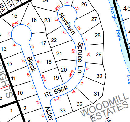
It’s difficult, but I’ve managed to use the FFX GIS site as a reference for street names and address locations. I much prefer Loudoun or Prince William GIS maps for ease-of-use reasons, but the Fairfax ones can get the job done.
Ah, thanks for that, I’ll check it out, as lately the area I’ve been trying to clean up actually borders Ffx. Co. and I need some info on a few residential streets right on the border.
I forgot to mention that I enhanced that section of FFX GIS map. The house numbers are not red on the maps you download from the website.
Yes I killed an hour or so fixing some stuff thanks to those maps, thanks again. Now I know if I need to find something in Ffx. Co. I can do it but you’re right, it is way more cumbersome than the Loudoun Co. maps. One downside to LC that I have noticed - the SR numbers on the roads are so small on my screen that it’s hard to read them, and zooming in doesn’t help. I guess I need a bigger monitor… (using a 17" laptop)
If you ever need to venture across the river, avoid the Montgomery County GIS site, which is useless for our purposes. Instead, use http://www.montgomeryplanning.org/gis/interactive/addressing.shtm